The first "historical" reference to Corfu occurs in the Odyssey. Odysseus is blown off course as he nears Ithaca and lands on the island of the Phaeacians where he is received and has a banquet in his Honor. On the island, Odysseus is surrounded by enchanting gardens and is given lavish gifts.
The original name of the island is Circyra (which shifted to Kérkira) which dates from the 8th century B.C. when the Corinthians founded a colony on the island. The colony was located on the top of a hill near the natural harbor on the eastern side of the island.
Corfu has known many invaders. One of the most notable was the Venetians who ruled the island from 1386 to 1797. Corfu was a logical port of call for ships traveling from Venice. It has a defensible harbor and a mild climate. During this time, Corfu Town (Kérkira in Greek) was built up (yes Greeks, the Venetians did build stuff on the Greek islands) and refortified the "old citadel" south of the harbor to become their principal castle. The Turks repeatedly tried to invade the island but were beaten back several times. Most notable was in 1716 when a mixture of Greeks, Venetians (and other Italians), Slavs and Germans beat them back.

Corfu quickly went to French then Turkish hands until becoming a British protectorate in 1814. Though the British controlled the island for the next fifty years, a rebirth of Hellenism spread through the island, including a conversion to the Orthodox religion.
Though it had almost six hundred years of foreign rule, the island was traditional a Greek Island
and the islanders spoke Greek. When mainland Greece became an independent state Corfu, along with the other Ionian Islands was ceded to the independent Greek state.Corfu is the most visited Ionian island, often via the Italian ferryboats. Unfortunately many people head for the south or to the infamous Pink Palace and miss the true beauty of the North that Gerald Darrel wrote about.
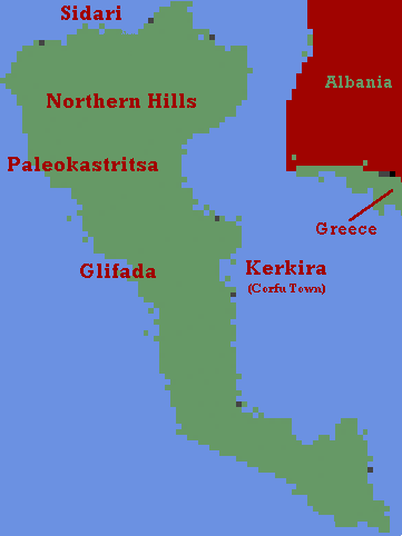
I have visited the island two times. As you can see, most of my travels were to the north west of the island. Therefore, my photos show mostly those areas. Sadari is a resort on the northern coast with awesome views of the Adriadic sea. The Glifada area is a set of resorts on the western side of the island. In my opinion this areas has the second most attractive beaches on the island. Paleokastritsa is in my opinion the most scenic area part of Corfu. It has steep winding roads that lead to a very attractive beach. Corfu Town is a terrific example Venetian town. I have also included scenic road shots from the hills up north. I did travel down to the southern part of the island. The reason for my lack of photos is because the south west was uninspiring and the southeast was full of resort hotels.
